
SPECIAL TRAFFIC ADVISORY
PLEASE NOTE: Maps and other information will be updated closer to race weekend, 2026.
Roads in Victoria and Oak Bay will be impacted on Saturday, October 10 and Sunday, October 11 as part of the Royal Victoria Marathon.
We thank you for your patience on both these days as over 15,000 runners and walkers take to the streets of Victoria. Please read through the Road Closure information below. We have also added a number of key area maps that will help you navigate around the course.
TCP and Police will assist with road crossing where possible. See below for locations where these personnel will be in place.
IMPORTANT:
NO PARKING is allowed on the race routes. Special event no parking signs will be put up in the City of Victoria and in the Municipality of Oak Bay. Sunday morning, cars will be towed from the course starting at 12:01am. Where possible, we recommend parking your car outside of the race route, paying attention to the no event parking signs. Oak Bay, please look at road signage carefully as there are road closures on both Saturday and Sunday.
VENUE CLOSURES SATURDAY OCTOBER 10 & SUNDAY OCTOBER 11 - DOWNTOWN VICTORIA:
Saturday, October 10 10:00am until Sunday, October 11 7:00pm - Extended COMPLETE road closures for set up, races and take down of the start/finish area of the Royal Victoria Marathon. Belleville - Oswego to Government and Menzies - Belleville to Quebec (City of Victoria)
Venue map for Sunday, October 11 is below
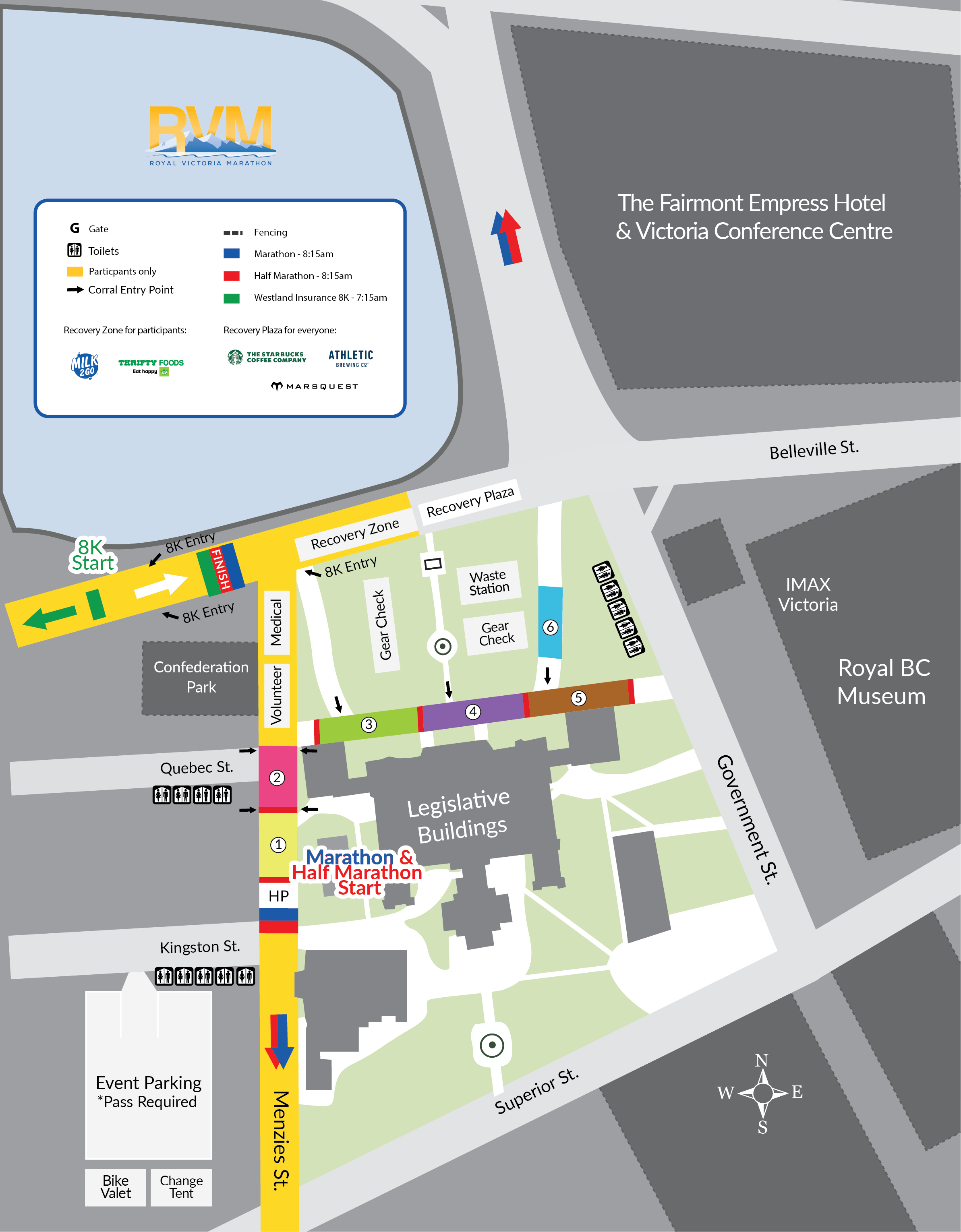
CLICK HERE for printable version of venue map.
ROAD CLOSURES SATURDAY OCTOBER 10 - OAK BAY:
Saturday, October 10 2026 - Extended COMPLETE road closures for set up, plus the running of the 5K and Thrifty Foods Kids Run. There is NO PARKING on the race route from 5:00 am to Noon.
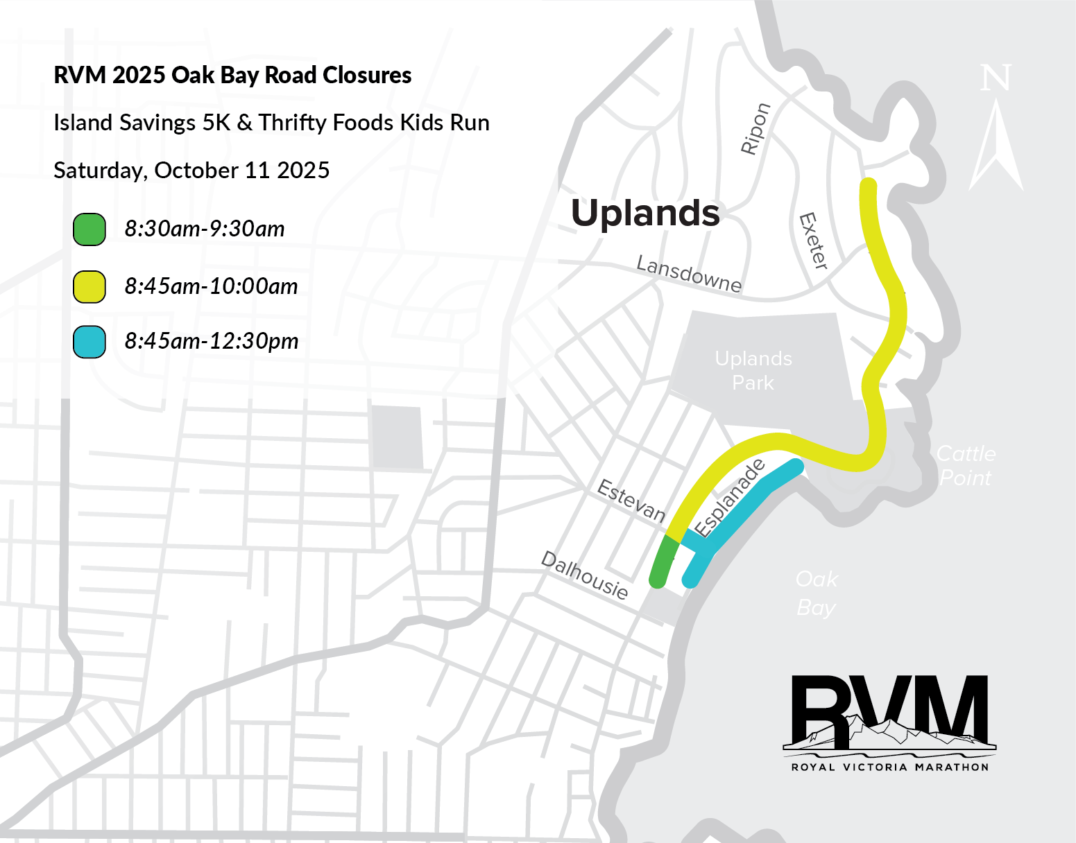
CLICK HERE FOR PDF VERSION TO PRINT OFF
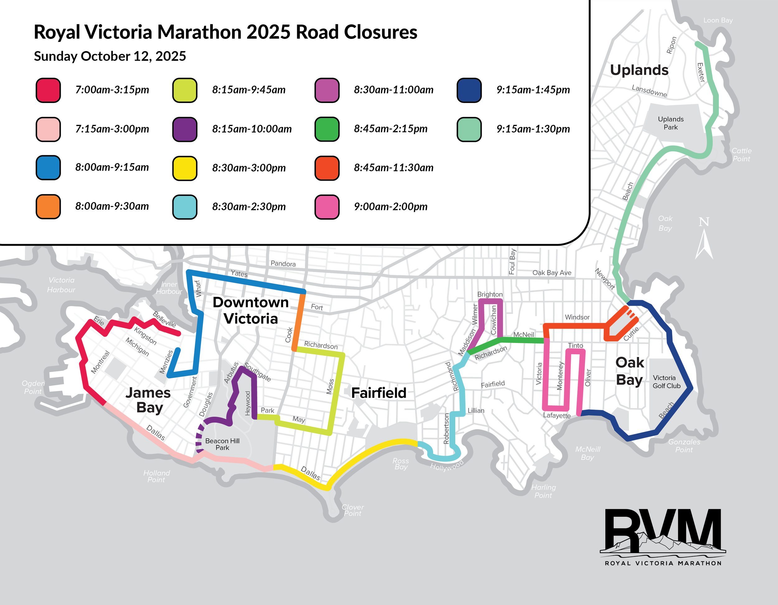
ROAD CLOSURES SUNDAY OCTOBER 11 - RACE ROUTES, VICTORIA AND OAK BAY
Times for Sunday road closures are approximate but there will be runners/walkers on the roads from 7:00am - 3:15pm. Roads will reopen on a rolling schedule shortly after the last participant passes and course infrastructure is removed.
-
Once the races start, traffic personnel will assist you at the major route crossings as indicated below, when it is safe to do so. Please expect delays in crossing.
Major controlled route crossings Sunday by Police or Traffic Control Professionals:
- across Yates at Douglas, Blanshard and Quadra - re-opens 9:15am
- across Cook at Fort - re-open 9:30am
- across Moss at Fairfield - re-open by 9:45am
- across Robertson at Ross/Crescent - re-open by 2:30pm
- across Richmond at Fairfield - re-open by 2:15pm
- across Richardson/McNeill at Foul Bay - re-open by 2:00pm
- along Beach Dr from Margate to the hotel and golf course - re-open by 2:00pm
PLEASE NOTE: In Oak Bay on Sunday, both traffic lanes on Newport (beside Windsor Park) are open. text goes here
-
CLICK HERE for more detailed information
-
-
On race day, road closures within the downtown core will be in effect downtown between 7:00 AM and 9:30 AM. If you are traveling to Harbour Air, BC Ferries, or the CoHo Ferry and are not participating in the race, please allow extra time and use the directions below.
CLICK HERE for printable version of this information.
Getting to Harbour Air (950 Wharf St.). Greatest potential delays: 8:00–9:30 AM.
Walking
From James Bay: 10–15 minutes via Government St. or Menzies St. The main venue area is on Menzies from Kingston to Belleville.
From Fairfield: 20–25 minutes via Cook St. or Vancouver St., then to Wharf St. Avoid Cook street from Richardson to Yates.
Cycling
From James Bay or Fairfield, use Cook St. (avoid Cook from Yates to Richardson) or Vancouver St. to get downtown. Bike racks are available near Harbour Air.
Transit
From James Bay: Take the #2 bus, get off at Government & Belleville, then walk 5 minutes.
From Fairfield: Take the #7 bus along Fort St., then walk a few minutes to Wharf St.
Driving
From James Bay: Use Douglas St. north, then Broughton St. Police will assist with crossing into the Inner Harbour.
From Fairfield: Use Fairfield Rd. to Broughton St. Police will assist with crossing into the Inner Harbour.
Parking will be limited. Avoid Yates, Wharf, Cook, and Government St.
Taxi / Rideshare
Drop-offs at Harbour Air are permitted. Drivers may be rerouted, but police will help direct vehicles to cross points. Avoid Menzies, Michigan, Government, Wharf, Yates. Cook is accessible south of Richardson.
Tip: Walking or biking is usually the fastest way. Driving is possible with police assistance at Broughton St.
Getting to BC Ferries (Swartz Bay Terminal). Greatest potential delays: 8:00–9:30 AM.
Driving
From James Bay: Use Superior St. to Douglas St. northbound (Highway 1). Follow signs to Swartz Bay. Police will be stationed at Douglas and Blanshard (8:00–9:15 AM) to assist with crossings when possible. Expect delays.
From Fairfield: Use Fairfield Rd. eastbound, connect to Cook St. or Yates St. Vehicles will be allowed to access Yates @ Cook toward Pandora. Continue to Blanshard St. (Highway 17) north to the terminal. Police will assist at crossing points.
Taxi / Rideshare
Taxis and rideshares may cross at controlled intersections. Let your driver know you are heading to BC Ferries, and they will be guided toward Highway 17.
Transit
BC Transit routes #70 (Swartz Bay Express) and #72 (Swartz Bay/Sidney) will continue to operate with adjustments around downtown. Check BC Transit’s website for detours.
Tip: Allow at least 30 extra minutes. Use Blanshard St./Highway 17 directly whenever possible.
Getting to the CoHo Ferry (430 Belleville St.). Greatest potential delays: 7:15–9:30 AM.
Driving
From James Bay: Use Superior St. to access Oswego St. northbound. Traffic Control Personnel (TCPs) will be stationed at Oswego to assist vehicles crossing to the terminal.
From Fairfield: Use Fairfield Rd. toward downtown. Connect to Douglas St. or Blanshard St., then take Superior to Oswego St. TCPs will assist at Oswego. Best to arrive before 7:15 AM to avoid delays.
Walking / Cycling
From James Bay or Fairfield, walk or bike toward Belleville St. via Government or Menzies St. The main venue area is located on Belleville between Government and Oswego, as well as, Menzies between Belleville and Kingston.
Taxi / Rideshare
Taxis and rideshares will be directed to Oswego St., where TCPs will assist with terminal access.
Tip: Walking or biking is often the quickest option if you are staying nearby.
Getting to Victoria International Airport (YYJ). Greatest potential delays: 8:00–9:30 AM.
Driving
From James Bay: Take Superior St. to Douglas St. northbound. Continue onto Blanshard St./Highway 17 and follow it straight to YYJ. Traffic Control Personnel (TCPs) will assist at key crossings as needed.
From Fairfield: Use Fairfield Rd. and connect to Cook St. or Yates St., then head to Blanshard St. (Highway 17) north to the airport. Avoid Cook street from Yates to Richardson. Yates will remain open at Cook street to head toward Pandora.
Taxi / Rideshare
Permitted through controlled intersections. Let your driver know you’re heading to YYJ; they’ll be routed toward Highway 17.
Transit
BC Transit provides service to YYJ; downtown detours may apply on race morning. Please check BC Transit for day-of schedules and detours.
Tip: Build in 30–45 extra minutes on race morning. Using Blanshard St./Highway 17 is the most direct route to the airport. Police will assist with crossing when safe to do so.